Christaller Central Place Theory Explained: Definition, Examples & Key Insights
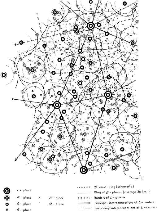
Christaller central place theory is one of economic geography's most elegant attempts to explain why towns and cities of different sizes exist in predictable patterns. Developed by German geographer Walter Christaller in 1933, the theory argues that settlements function as central places providing goods and services to surrounding hinterlands. Instead of treating urban growth as random, Christaller proposed that market forces, transport costs, and administrative needs arrange settlements into a hierarchy of nested service areas. The result, in its purest form, is a landscape of hexagons: a geometric expression of how far people will travel for bread, shoes, medical care, or a specialized concert.
More than eight decades later, the theory still appears in urban geography, retail analysis, regional planning, and locational economics. It helps explain why a village may support a convenience store but not a hospital, while a regional city can sustain a symphony orchestra and an international airport. The model is not a literal map of every modern metropolis, yet its core questions remain urgent: What draws consumers to a center? How far will they travel? And what minimum population is needed to keep a service alive?
Origins and Core Logic of Christaller Central Place Theory
Christaller introduced his ideas in Die zentralen Orte in Süddeutschland, a study of settlement patterns in southern Germany. He was interested in why certain places offered more functions than others and why those places were spaced in regular ways. Rather than beginning with history or culture, he built a deductive model from economic behavior. A central place, in his framework, is any settlement that provides goods and services to a surrounding area, known as its complementary region.


The theory rests on a simple spatial bargain. Consumers want to minimize the distance they travel for a good, while providers want enough customers to cover costs. When many consumers and firms make these choices across a uniform region, competition pushes service areas into hexagonal shapes. Each center serves a surrounding market, and larger centers serve broader markets that contain smaller ones. This nesting is the engine of the urban hierarchy.
Walter Christaller and the 1933 Study
Walter Christaller was a German geographer whose dissertation became a landmark in spatial science. He used telephone connections as a practical indicator of central functions, counting how many lines a settlement had as a rough measure of its importance. That choice was clever for the 1930s because telephone access reflected commercial, administrative, and professional activity. From those patterns, he identified a ranked system of central places rather than a simple urban-rural divide.


His work was later translated and absorbed into English-language geography, where it influenced regional science, retail location theory, and planning models. Scholars such as August Lösch extended the geometry of market areas, while planners used central place ideas to think about service provision. The 1933 study remains a reference point because it turned settlement patterns into a testable economic theory.
The Isotropic Plain and Rational Consumer Assumptions
To make the model work, Christaller imagined an isotropic plain: a flat, featureless surface with evenly distributed population, equal purchasing power, and uniform transport costs. Consumers were assumed to be rational and to shop at the nearest center that offered the good they wanted. Firms were assumed to seek maximum profit and to locate where demand was sufficient. These conditions remove real-world noise so that the underlying spatial logic can be seen clearly.
The assumptions are deliberately unrealistic, but they are not arbitrary. They allow the theory to isolate how distance, demand, and competition shape settlement size and spacing. In practice, mountains, coastlines, political borders, cultural preferences, and online shopping distort the neat hexagons. Even so, the assumptions provide a baseline for asking why actual patterns deviate and which forces matter most.



Threshold, Range, and the Hexagonal Landscape in Christaller Central Place Theory
Two concepts do most of the explanatory work in central place theory: threshold and range. The threshold is the minimum amount of demand, often measured as population or income, needed for a service to be economically viable. The range is the maximum distance that consumers are willing to travel for that service. A central place can support a good only when enough customers fall within its range to meet the threshold.
These two variables sort goods and services into orders. Low-order goods, such as milk, bread, or basic banking, have low thresholds and short ranges, so they appear in many small centers. High-order goods, such as specialized surgery, universities, or international airports, have high thresholds and long ranges, so they cluster in fewer, larger centers. The result is a hierarchy of central places, from hamlets and villages to towns, cities, and regional metropolises.
Threshold, Range, and the Urban Hierarchy
Threshold and range interact to determine which functions a settlement can sustain. A small town may have enough nearby customers for a grocery store and a primary school, but not enough for a rare disease clinic. A regional city draws from a much larger complementary region, so it can support hospitals, universities, theaters, and specialized retail. Higher-order centers also tend to provide all the lower-order functions found in smaller places, which makes the hierarchy cumulative.


This explains familiar patterns in everyday life. Most neighborhoods have convenience stores, some have supermarkets, and fewer still have luxury boutiques or convention centers. The same logic applies to public services: post offices, courts, and hospitals are distributed according to population thresholds and travel ranges. When planners close or open facilities, they are often making implicit judgments about threshold, range, and equity of access.
K Values, Nested Hexagons, and Real-World Evidence
Christaller described three organizing principles using K values. In the market principle, K equals 3, meaning a higher-order center serves itself plus one-third of each of six neighboring lower-order centers. In the transport principle, K equals 4, which favors centers along efficient transport routes. In the administrative principle, K equals 7, where lower-order centers are fully controlled by a higher-order center and boundaries do not split local authority.
Real-world evidence is mixed but instructive. Studies of retail chains, healthcare facilities, and school districts often find hierarchical spacing, especially in relatively uniform agricultural regions. In mountainous or densely urbanized areas, the hexagons break down. E-commerce adds another complication because consumers can travel zero miles for goods that once required a trip to town. Still, the K-value logic remains useful for comparing how market, transport, and administrative forces compete to shape settlement patterns.
Christaller's central place theory continues to reward anyone who looks at a map and wonders why services cluster where they do. It offers a disciplined way to connect consumer behavior, transport cost, and urban hierarchy without pretending that every city fits a perfect geometric plan. For students, planners, and retailers, the theory is best used as a diagnostic tool: test the assumptions, measure the thresholds, trace the ranges, and then ask which real-world forces are bending the hexagons. That habit of inquiry is why a 1933 dissertation still speaks to modern debates about access, growth, and the shape of daily life.
Related Articles

Restorative Theory Explained: Definition, Examples, and Key Insights
Restorative theory is a framework for understanding harm, accountability, and healing that has moved from the margins of legal scholarship into mainstream...
Central Place Theory Example: Real-World Cities and Everyday Applications Explained
Central place theory example is more than a textbook map of hexagons; it is a way to see why some towns have a hospital and others only a gas station...

Central Force Explained: Definition, Formula, Examples & Key Concepts
Your quota is exhausted. API key status: exceeded Name: PCTB8QC8QS7ST Quota: 0/3200000000 tokens (0.0%) exp_date: 2026-10-17T14:27:58.134Z

Biotic Biotic Factors Explained: Definition, Examples, and Ecosystem Impact
Biotic factors are the living components of an environment — every plant, animal, fungus, bacterium, and microscopic organism that influences the survival of...

Encoding Communication Definition: Meaning, Process, and Examples Explained
Your quota is exhausted. API key status: exceeded Name: PCTB8QC8QS7ST Quota: 0/3200000000 tokens (0.0%) exp_date: 2026-10-17T14:27:58.134Z

Forage Crop Definition: Meaning, Types, and Examples Explained
Forage crop definition: a forage crop is a plant grown primarily to provide feed for livestock, usually through grazing, browsing, or mechanical harvest of its...